Researchers of the University Hospitals in Ohio, USA, published a study in the European Heart Journal. In this study, they presented the results of the most interesting monitoring program. They monitored heart health employing Google Street View.
With Google Street View, the scientists monitored everyday surroundings. This included the quality of roads, buildings, common and green spaces. Then, they were able to link this data to the data on cardiovascular diseases in the analyzed neighborhoods. This is how Google Steet View was linked to heart health.
The conclusions of this research are not only interesting but can also play a significant role in future urban planning. They determine the role of the built environment in our heart health. The scientists identified specific neighbourhood characteristics that can account for 63% of the differences in heart disease risk from one community to another.
Further, researchers identified the link between presence or absence of pollution, and the risk of coronary heart disease (CAD). It is a health condition where the heart’s arteries are blocked. A build-up of fatty substances in the coronary arteries interrupts the blood supply to the heart. This limits blood flow to the heart. It is one of the most common forms of cardiovascular disease.
CAD and high blood pressure
- Hypertension is a major risk factor for the development of CAD. Epidemiological data shows a strong and consistent link between hypertension and CAD.
- Hypertension can promote the development of coronary atherosclerosis and lead to narrowing of the coronary arteries (coronary lumen stenosis). This can limit blood flow and oxygen supply to the heart muscle.
- High blood pressure, especially high systolic blood pressure, can also lead to myocardial fibrosis, ischemia, and cardiac hypertrophy, further contributing to the development of CAD.
- Hypertension and CAD often coexist due to shared risk factors and pathophysiological mechanisms. Patients with both conditions have worse outcomes and prognosis compared to those with only one condition.
Google and Heart Health: How it was done
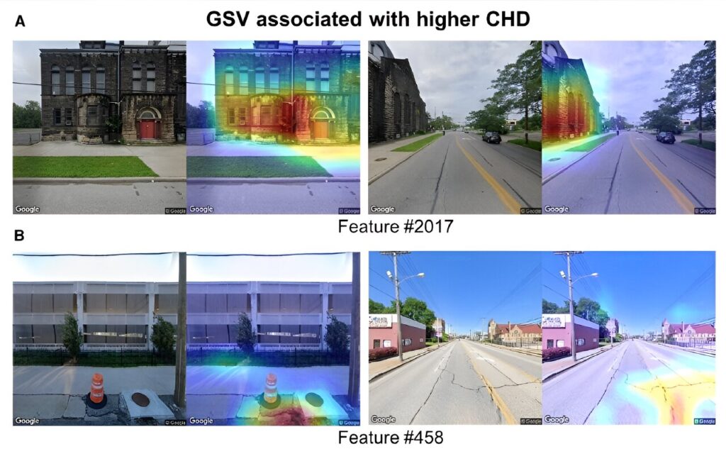
The methods employed in the study were also very interesting.The discovery originates from the analysis of over half a million Google Street View images in several US cities, to link it to heart health.
The study analyzed more than half a million Google Street View images of Detroit, Michigan; Kansas City, Missouri; Cleveland, Ohio; Brownsville, Texas; Fremont, California; Bellevue, Washington State; and Denver, Colorado.
Researchers collected data on rates of coronary heart disease in the so called census tracts. Census tracks are areas smaller than an individual US ZIP code. They are typically homes to an average of 4,000 people.
The researchers used a convolutional neural network. It is a type of artificial intelligence that can recognize and analyze patterns in images to make predictions. The scientists used AI based computer vision to identify and interpret details too small for a human eye.
Researchers say that Google Street View helped them provide an overview of physical environmental risk factors in the built and natural environments. Ultimately, it can not only help in understanding the risk factors, but help towards building new or adapting existing towns and cities. The aim is to make them healthier places to live.
Citations by the study’s authors
The study was led by Prof. Sadeer Al-Kindi and Prof. Sanjay Rajagopalan from University Hospitals Harrington Heart & Vascular Institute and Case Western Reserve University, Ohio, U.S., and Dr. Zhuo Chen, a post-doctoral fellow in Prof. Rajagopalan’s laboratory.
Prof. Rajagopalan said, “We have always been interested in how the environment, both the built and natural environment, influences cardiovascular disease. Here in America, they say that the ZIP code is a better predictor of heart disease than even personal measures of health. However, to investigate how the environment influences large populations in multiple cities is no mean task. Hence, we used machine vision-based approaches to assess the links between the built environment and coronary heart disease prevalence in US cities.”
Prof. Al-Kindi added, “We also used an approach called attention mapping, which highlights some of the important regions in the image, to provide a semi-qualitative interpretation of some of the thousands of features that may be important in coronary heart disease. For instance, features like green space and walkable roads were associated with lower risk, while other features, such as poorly paved roads, were associated with higher risk. However, these findings need further investigation.
“We’ve shown that we can use computer vision approaches to help identify environmental factors influencing cardiovascular risk and this could play a role in guiding heart-healthy urban planning. The fact that we can do this at scale is something that is absolutely unique and important for urban planning.”